
Record cold slammed the tri-state Friday morning as a "Siberian express" of arctic air and blasting winter winds plunged temperatures across the region more than 20 degrees below seasonal averages, and more wintry weather is in store for the weekend, Storm Team 4 says.
It was the coldest Feb. 20 on record in several locations across the tri-state as the arctic system pushed down from Canada, bringing bitter and gusty winds as far south as Florida.
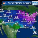
The mercury dipped to 2 degrees in Central Park, marking the lowest Feb. 20 temperature seen in the park since Jan. 2004 and shattering a previous record low for the day set in 1950. The lowest temperature ever recorded in Central Park was negative 15 degrees on Feb. 9, 1934. During the winter of 1899, subzero temperatures were measured at Central Park three times in February.
In addition to the record Feb. 20 low at Central Park, record daily lows were observed at the region's three airports, Islip on Long Island and in Bridgeport, Connecticut.
Temperatures across New Jersey dropped to zero degrees, while most of Long Island hit the low single digits. In the Hudson Valley and Connecticut, temperatures dropped below zero. Monticello, New York, saw the tri-state's lowest temperature reading as the mercury dropped to 8 below zero.
Blistering wind gusts made it feel colder, with wind chills as low as 25 degrees below zero in some areas. The wind made walking difficult in New York City, stinging commuters' faces, while the record cold created icy conditions on the waterways around Manhattan and caused ferry disruptions.
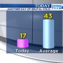
Highs only make it to the upper teens in the warmest parts of the region, which Storm Team 4 says is about 25 degrees below average temperatures for late February. Harsh, constant winds made it feel more like 6 degrees in midtown.
[[289864051, C]]
Temperatures are expected to climb back above the freezing mark Saturday as another winter system moves into the area. Snow is expected across the tri-state beginning in the early afternoon, but the flurries won't last more than a few hours, Storm Team 4 says. Areas along the immediate coastline -- south shores of Brooklyn, Queens, Long Island and Connecticut -- may get a slight coating to 1 inch of snow before the precipitation changes over to rain. A wintry mix is expected to linger inland, and Storm Team 4 forecasts about 2 to 4 inches of snow from the north shore of Long Island to the city and immediate northwestern suburbs. The snow will stick quickly because of the recent arctic snap and driving could be treacherous Saturday evening, Storm Team 4 says.
Any snow in the city and surrounding suburbs should change to sleet and rain late Saturday. Areas north and west of the city will get the brunt of the storm and may see 4 to 6 inches.
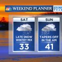
The mercury should reach 40 degrees or higher, Storm Team 4 says, but more brutal cold will be quick to follow. Another blast of arctic air is expected to rush into the area Sunday night into Monday, Storm Team 4 says, sending temperatures back into the lower 20s to start the week.
Local


If the cold weather continues through the next week, Storm Team 4 says it could make this month one of the coldest Februarys on record in New York City and the surrounding region. The average temperature in Central Park is 24.4 degrees so far this month, 10 degrees below average.
The coldest February ever recorded in the city was in 1934, when the average monthly temperature in Central Park was 19.9 degrees.

![[NATL-NY] Girl's Burns, Blisters "Wasn't What I Thought Frostbite Would Look Like": Mom](https://ots.nbcwpshield.com/wp-content/uploads/2019/09/7944747_N6PPKGLAAUTOSHOWGAD_722x406_2168176206.jpg?fit=722%2C406)
![[NATL-NY] "Ice Volcano" Forms at Geyser in Upstate New York Park](https://ots.nbcwpshield.com/wp-content/uploads/2019/09/howie_mandel.jpg?fit=722%2C406)