UPDATE: 6 to 12 Inches Possible for Much of Tri-State; Storm Team 4 Breaks Down Expectations, Timeline
Storm Team 4 is tracking the possibility of a significant winter storm for the tri-state starting Wednesday night as a winter storm watch was issued for late Wednesday night into Thursday afternoon.
The National Weather Service issued the watch for New York City, Long Island, northeast New Jersey, the lower Hudson Valley and southern Connecticut, warning travel could be hazardous due to the snow-covered roads and poor visibility.
Up to 6 to 10 inches of snow could fall, though meteorologists caution the track of the system remains highly uncertain.
The first forecast for the region includes a wide swath that could see as much as a foot of snow, including the five boroughs of New York City.
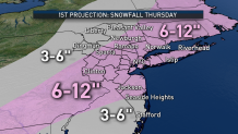
Much remains uncertain about the storm, though as of Tuesday afternoon it appears the balance will fall over a period of six to eight hours, starting with Thursday's commute.
Local

In the meantime, the tri-state will deal with rain and a wintry mix Tuesday.
Some rain fell overnight in the city and near the Jersey Shore, with minor snow and ice accumulations building up north and west, though Storm Team 4 says the steadiest rain will fall during the middle of the day Tuesday.
[NATL] Extreme Weather Photos: Record Heat Threatens Europe
Spotty light showers will continue across the area Tuesday night before tapering off Wednesday morning.
Wednesday will be breezy and mild with mostly cloudy skies and an unseasonable high of 60 degrees. Temperatures dive back into the 30s Thursday.